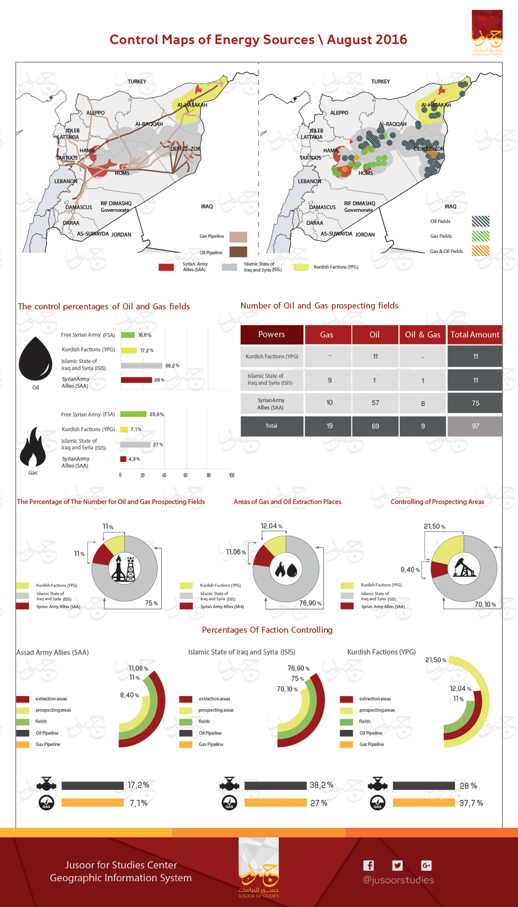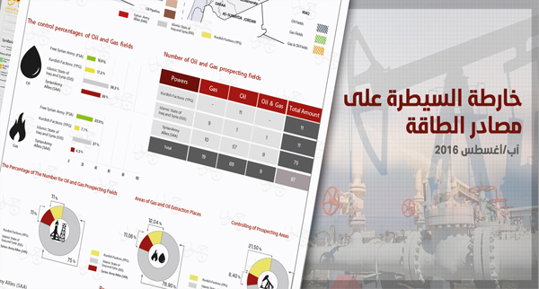
Control Maps of Energy Sources August 2016
Analysis the Map of Energy Sources
Jusoor for Studies is seeking to study and clarify the effect of the current military conflict on various aspects of the Syrian reality and based on the importance of the energy sources in supplying the fighting parties with the necessary cash money to continue the military actions and supply the military equipment with fuel and provide the requirements of fighters
The center has studied how the disputing parties control of the oil and gas wells through prospecting and extraction and of oil and gas pipelines. The center also estimated the percentages of areas that each party control which led to issue a map showing these data and summarizing the current energy situation in Syria
according to the map, the places of oil and gas fields in Syria for prospecting and extracting are limited mainly on these three provinces respectively which are: Deir Al Zour, Homs specifically in its eastern desert and Al Hasakah and some relatively presence in the southern areas of Al Raqqa, in the Administrative borders with Homs and Deir Al Zour.
ISIS, Kurdish factions, and Assad forces monopolize controlling of gas and oil fields and wells without any controlling for the opposition forces on the energy sources especially after totally lose their areas in the eastern and north eastern areas where most of energy sources concentrate there, and they lost these areas after Strong battles against ISIS and Kurdish factions
the total of oil and gas fields in Syria are 97 fields.75 of them are under controlling of ISIS while the Kurdish factions and Assad forces dominate the same number of fields and wells (11 fields for each of them).
According to this information the percentage of each party controlling on the prospecting and extracting of oil and gas vary to reach the maximum in extracting as following: the extraction by ISIS (about 76.90%) then the Kurdish factions (about 12.04%) then Assad forces (about 11.06%).
This map comes after the map of road network issued by Jusoor for studies on 15 June 2016 to reveal that in spite of there are not a lot of main and sub roads and the law population in a lot of areas that controlled by ISIS but these areas have the highest amount from gas and oil fields and wells ,and this forms the largest source of money comparing with the other sources it have and which include extortion, taxation ,kidnapping ,ransom and stealing antiquities (review our translation for the article ” why ISIS will have excess of money for many years next”)
This map also reveals how the regime controlling on energy sources became weak and how this controlling related to the main supporters for regime which are (Russia and Iran) to provide him with his military needs and the requirements of areas under his control especially because these areas have the highest population.
And for the Kurdish factions, the map shows that their domination on energy sources are very small but comparing to their totally and effectively control areas as shown in the military influence map for July, and comparing to the limited population in their areas, so these sources are considered fairly enough and serving their military and financial needs.